Exploring the great outdoors can be a transformative experience, whether you’re navigating dense forests, scaling towering peaks, or setting up camp under a starlit sky. The thrill of adventure, the serenity of nature, and the challenge of the wilderness beckon to those seeking a break from the hustle and bustle of everyday life. However, to truly immerse yourself in nature and ensure a safe adventure, having a reliable topographic map is crucial. A map not only guides you through unknown terrains but also enhances the overall experience by revealing hidden gems along the way. In this guide, we’ll delve into some of the best camping and hiking topographic maps available today.
Understanding Topographic Maps
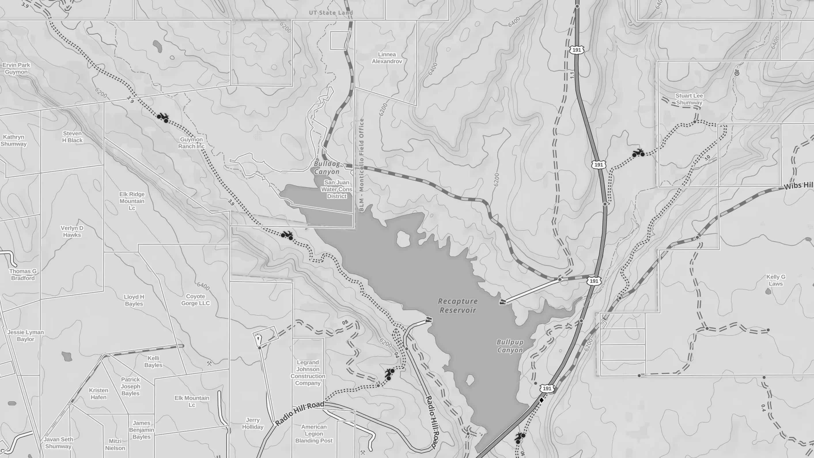
Topographic maps are detailed, large-scale maps that show natural and man-made features of the land. They offer a bird’s-eye view of the terrain, providing critical information for outdoor enthusiasts. These maps are essential for hikers and campers as they illustrate terrain relief, elevation, and landforms, allowing adventurers to navigate the wilderness effectively. Understanding how to read these maps can make the difference between a successful outing and a disorienting experience.
The Role of Contour Lines
Contour lines are one of the most important features on a topographic map. These lines depict elevation changes and landform shapes, providing a three-dimensional view on a two-dimensional surface. The closer the lines, the steeper the terrain, which helps hikers determine the difficulty of a trail and anticipate changes in elevation. Understanding contour lines can help you plan the most efficient route and avoid unexpected challenges.
Deciphering Scale and Distance
The scale of a topographic map provides the ratio of a map distance to the actual ground distance. This crucial feature helps adventurers estimate the time and effort required to traverse a particular area. A larger scale means more detail and a smaller area, while a smaller scale covers a larger area with less detail. Knowing how to read and interpret the scale ensures you can accurately gauge distances and plan your journey accordingly.


Symbols and Colors: A Visual Language
Symbols and colors on a topographic map represent different landforms and man-made features like forests, water bodies, and roads. These visual cues help you quickly identify landmarks and navigate through diverse terrains. For example, green often denotes vegetation, blue indicates water bodies, and black or red marks roads and trails. Familiarizing yourself with these symbols enhances your ability to read the map effectively and make informed decisions during your adventure.
Top Topographic Maps for Hiking and Camping
When it comes to choosing a topographic map, the right selection can make all the difference. A well-chosen map provides accurate details and enhances your understanding of the terrain, ensuring a safe and enjoyable experience. Here are some of the best options available, each offering unique features tailored to specific regions and activities.
Weminuche Wilderness West – Colorado Topographic Hiking Map (2019)
Situated in Colorado, the Weminuche Wilderness offers some of the most breathtaking landscapes. This topographic map provides accurate details of trails, campsites, and natural features, making it a must-have for any explorer planning to traverse this region. The map’s comprehensive coverage ensures you can confidently explore the wilderness, from its verdant valleys to its towering peaks.


Mount Zirkel Wilderness – Colorado Topographic Hiking Map (2024)
Known for its rugged beauty, the Mount Zirkel Wilderness is a popular destination for hikers seeking a challenge. The 2024 edition of this topographic map includes updated trail information and elevation changes, ensuring that adventurers can navigate the area with confidence. With this map, you can explore the area’s diverse ecosystems, from alpine meadows to dense forests, while keeping track of your progress.
Indian Peaks – James Peak Wilderness – Colorado Topographic Hiking Map (202X)
This map is essential for hikers planning to explore the Indian Peaks and James Peak Wilderness areas. With detailed terrain information and marked trails, it helps adventurers discover the stunning vistas and hidden gems of this Colorado wilderness. Whether you’re a seasoned hiker or a novice explorer, this map provides the guidance needed to fully enjoy the area’s natural beauty.
Specialty Maps for Specific Activities
While general topographic maps are essential for navigation, specialty maps can enhance your outdoor activities. These maps are designed with specific interests in mind, providing detailed information tailored to particular pursuits. Here are some to consider, each offering unique insights and features for enthusiasts of various activities.
Butler Maps for Motorcycling
Butler Maps are specifically designed for motorcyclists and provide detailed routes and scenic byways. Notable options include:
- Butler Maps G1 Regional Motorcycle Map (Southern California): Perfect for those looking to explore the diverse landscapes of Southern California. This map highlights the best routes for motorcyclists, offering a blend of challenging rides and stunning views.
- Butler Maps Wisconsin and Michigan’s Upper Peninsula: Ideal for riders seeking the scenic beauty of the Midwest. With this map, motorcyclists can discover hidden gems and enjoy the open road through some of the region’s most picturesque areas.
Fishing Hot Spots Map of Rainy Lake (Northern Section)
For fishing enthusiasts, the Fishing Hot Spots Map offers detailed insights into the northern section of Rainy Lake, helping anglers find the best spots to catch their trophy fish. This map provides information on water depths, fish species, and prime fishing locations, ensuring a successful and enjoyable fishing trip.
Azores Tour & Trail Super-Durable Map (2nd Edition)
If you’re planning a trip to the Azores, this super-durable map is your best companion. Its waterproof and tear-resistant design ensures it can withstand the elements, while providing detailed trail information for the adventurous traveler. With this map, you can confidently explore the stunning landscapes and unique geology of the Azores, from volcanic craters to lush forests.
Maps for Families and Educators
Topographic maps aren’t just for adventurers. They can also be educational tools that inspire curiosity and learning in both children and adults. By introducing topographic maps into educational settings, you can foster a deeper understanding of geography and navigation skills.
2-Sided Desk Map with Durable Lamination
This map is perfect for children and educational settings. Featuring a US-centered view, it’s laminated for durability, making it a great resource for learning geography and map reading skills. The map’s detailed representation of landforms and boundaries provides a hands-on learning experience, encouraging students to engage with the material and develop a love for exploration.
Interactive Maps for Classroom Use
Incorporating interactive maps into the classroom can enhance the learning experience by allowing students to visualize complex concepts. These maps often come with digital features that enable students to explore different terrains and landforms interactively. By engaging with these tools, students can better understand the intricacies of topography and develop critical thinking skills.
Family-Friendly Maps for Outdoor Adventures
Planning family outings with topographic maps can turn outdoor adventures into educational experiences. Family-friendly maps often include simplified symbols and explanations, making them accessible to younger explorers. By involving children in the navigation process, you can instill a sense of adventure and curiosity, while teaching them valuable skills for future explorations.
Combining Traditional and Modern Navigation
While topographic maps are invaluable, combining them with modern GPS technology can further enhance your outdoor experience. The integration of traditional and digital navigation tools provides a comprehensive approach to exploring the great outdoors. Here’s how you can make the most of both worlds.
GPS Devices: A Complementary Tool
Use a GPS device alongside your topographic map for real-time navigation and location tracking. GPS devices offer precise location data, enabling you to track your progress and make informed decisions on the go. By using both tools, you can cross-reference information and ensure accuracy in your navigation.
Mobile Apps: Offline Maps and GPS Tracking
Many mobile apps offer offline maps and GPS tracking, allowing you to plan routes and track your progress even without cell service. These apps often include additional features such as route planning, weather updates, and points of interest, enhancing your overall outdoor experience. By downloading maps in advance, you can ensure you have access to critical information regardless of connectivity issues.
Integrating Technology for Safety
Combining traditional maps with modern technology enhances safety during outdoor adventures. In case of emergencies, GPS devices and mobile apps can provide your exact location, aiding rescue efforts if necessary. By leveraging both traditional and digital tools, you can enjoy peace of mind, knowing you have reliable resources at your disposal.
Choosing the Right Map
When selecting a topographic map, consider the following factors to ensure you choose the best option for your needs. A well-chosen map enhances your experience and contributes to a successful outing.
Location: Focused Exploration
Choose a map specific to the area you’ll be exploring. Local maps provide detailed information about trails, landmarks, and terrain features unique to the region. By selecting a map tailored to your destination, you can plan your adventure with confidence and precision.
Activity: Tailored to Your Interests
Select maps tailored to your planned activities, whether hiking, camping, or motorcycling. Specialty maps provide information relevant to your interests, enhancing your overall experience. By choosing a map that aligns with your activities, you can focus on enjoying your adventure while having the necessary information at hand.
Durability: Withstanding the Elements
For harsh weather conditions, opt for waterproof and tear-resistant maps. Durable maps ensure you have reliable information regardless of environmental challenges. By investing in a map designed to withstand the elements, you can concentrate on your adventure without worrying about damage to your navigation tools.
Conclusion
Topographic maps are indispensable tools for anyone venturing into the great outdoors. From the rugged terrains of Colorado to the scenic routes of Southern California, the right map ensures a safe and enjoyable adventure. Whether you’re a seasoned hiker, a motorcycle enthusiast, or a family looking to explore nature, there’s a topographic map that fits your needs. Embrace the adventure with confidence, knowing you have the best navigation tool at your side. By combining traditional maps with modern technology, you can navigate the wilderness with ease and discover the beauty of the natural world.